Step 1.
The problem of those
list, is they don't have address infomation, don't have latitude, don't have longitude,
Can not be used into 911 CAD system.
Step 2.
To use in 911 CAD system, must have address and latitude and longitude along with agency name.
Common sense is if any of those
list in arcgis format, or in esri's arcgis REST api style, they should have latitude, longitude information along with it.
It is well know that USGS is agency that regularly collect and maintain national data set from all 50 states, 3000 counties and 13 other federal agencies.
USGS should have a trusted data set about national structure that you can use and download for free.
Step 3.
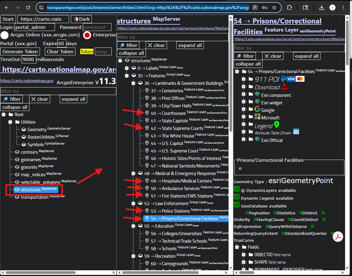
USGS list of law enforcement, healthcare
https://transparentgov.net/json2tree/esri/server/folder2.html?org=https%3A%2F%2Fcarto.nationalmap.gov%2Farcgis%2Frest%2Fservices&url=https%3A%2F%2Fcarto.nationalmap.gov%2Farcgis%2Frest%2Fservices&select_folder=7&select_layer=54&arcgis_online_token=&select_folder_text=structures+%3Csup%3EMapServer%3C%2Fsup%3E&select_layer_text=54+%26%23x21E2%3B+Prisons%2FCorrectional+Facilities+%3Csup%3EFeature+Layer%3Csub%3E+esriGeometryPoint%3C%2Fsub%3E%3C%2Fsup%3E
Step 4.
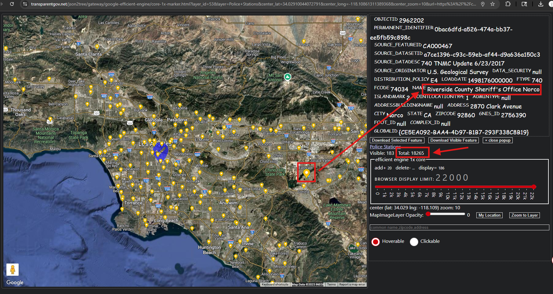
for example police station
https://transparentgov.net/json2tree/gateway/google-efficient-engine/core-1x-marker.html?layer_id=53&layer=Police+Stations¢er_lat=34.02910044072791¢er_long=-118.10861311389368¢er_zoom=10&url=https%3A%2F%2Fcarto.nationalmap.gov%2Farcgis%2Frest%2Fservices%2Fstructures%2FMapServer&panto=0
Step 5.
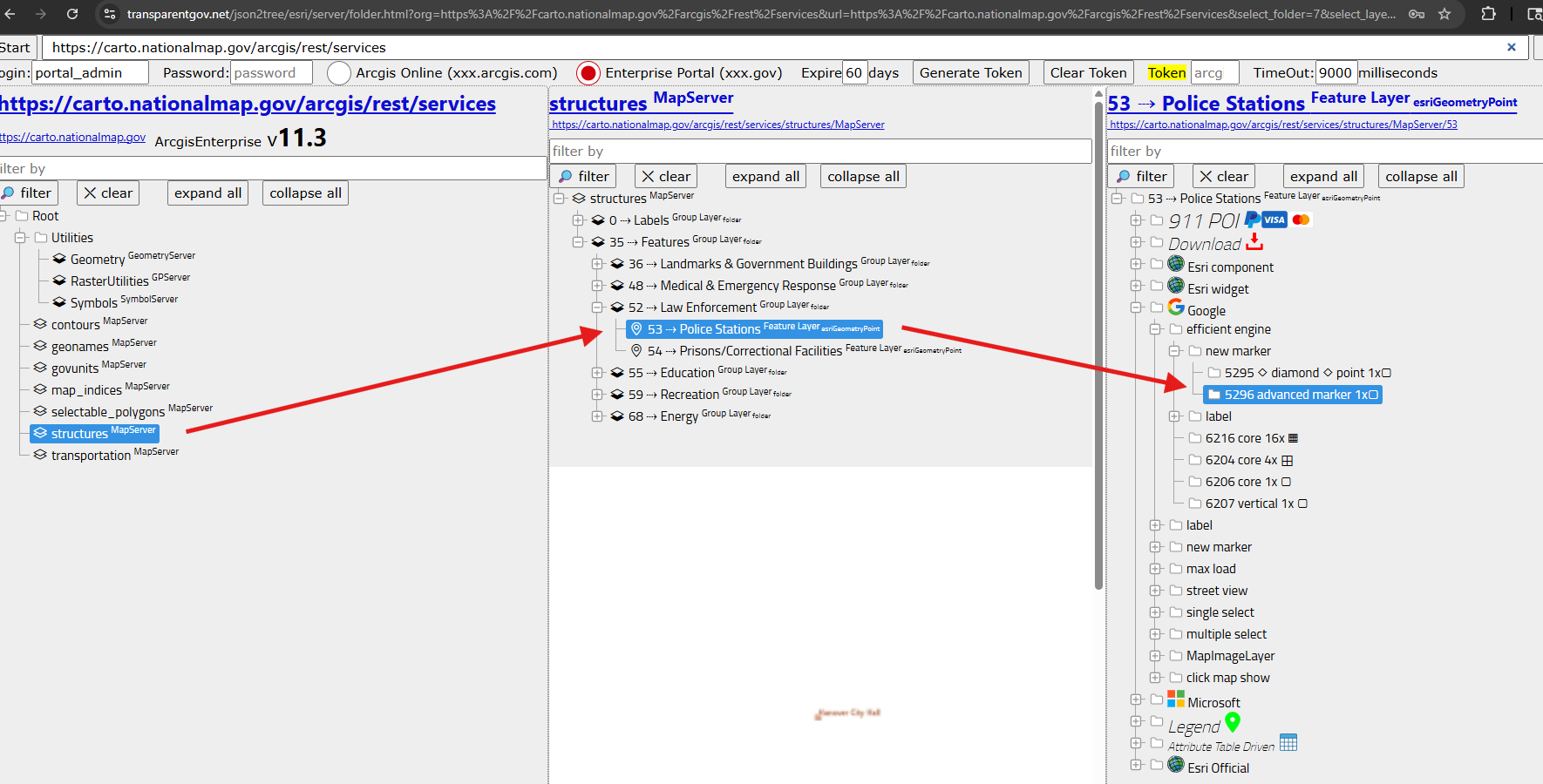
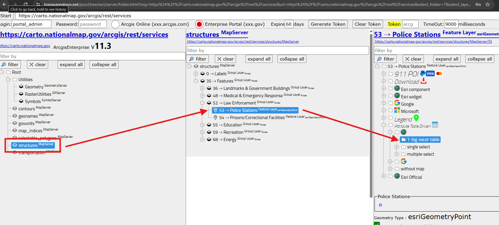
for example police station
https://transparentgov.net/json2tree/esri/server/folder.html?org=https%3A%2F%2Fcarto.nationalmap.gov%2Farcgis%2Frest%2Fservices&url=https%3A%2F%2Fcarto.nationalmap.gov%2Farcgis%2Frest%2Fservices&select_folder=7&select_layer=53&arcgis_online_token=&select_folder_text=structures+%3Csup%3EMapServer%3C%2Fsup%3E&select_layer_text=53+%26%23x21E2%3B+Police+Stations+%3Csup%3EFeature+Layer%3Csub%3E+esriGeometryPoint%3C%2Fsub%3E%3C%2Fsup%3E
Step 6.
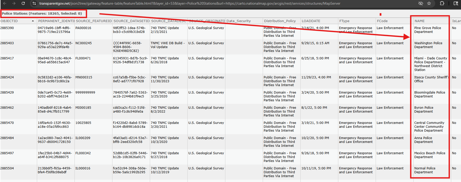
there are 18k police station, you can see it in excel style table here
https://transparentgov.net/json2tree/gateway/feature-table/featureTable.html?&layer_id=53&layer=Police%20Stations&url=https://carto.nationalmap.gov/arcgis/rest/services/structures/MapServer
Step 7.
there are 18k police station, you can see it in excel style table here
https://transparentgov.net/json2tree/esri/server/folder.html?org=https%3A%2F%2Fcarto.nationalmap.gov%2Farcgis%2Frest%2Fservices&url=https%3A%2F%2Fcarto.nationalmap.gov%2Farcgis%2Frest%2Fservices&select_folder=7&select_layer=53&arcgis_online_token=&select_folder_text=structures+%3Csup%3EMapServer%3C%2Fsup%3E&select_layer_text=53+%26%23x21E2%3B+Police+Stations+%3Csup%3EFeature+Layer%3Csub%3E+esriGeometryPoint%3C%2Fsub%3E%3C%2Fsup%3E
Step 8.
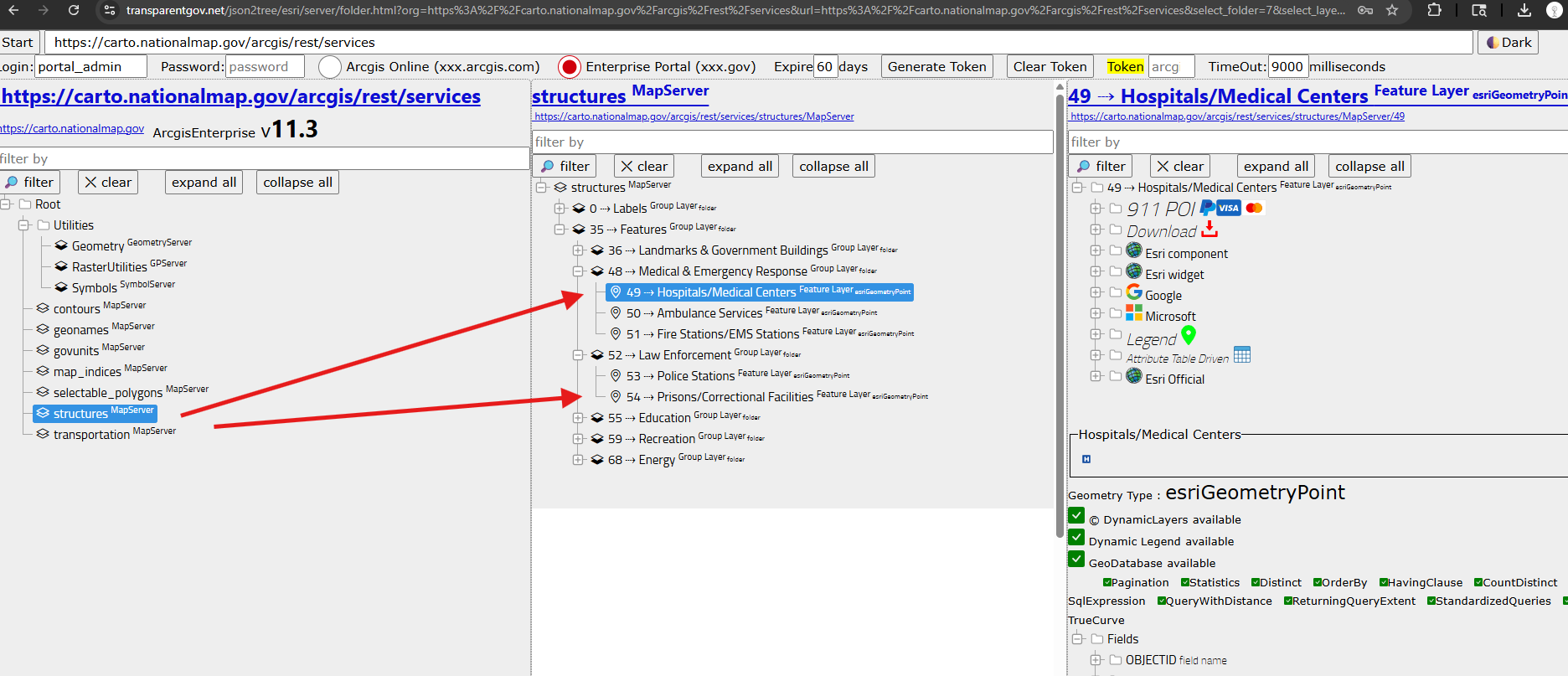
same idea, you can find hospital, jail, prision, court house in the same place
https://transparentgov.net/json2tree/esri/server/folder.html?org=https%3A%2F%2Fcarto.nationalmap.gov%2Farcgis%2Frest%2Fservices&url=https%3A%2F%2Fcarto.nationalmap.gov%2Farcgis%2Frest%2Fservices&select_folder=7&select_layer=49&arcgis_online_token=&select_folder_text=structures+%3Csup%3EMapServer%3C%2Fsup%3E&select_layer_text=49+%26%23x21E2%3B+Hospitals%2FMedical+Centers+%3Csup%3EFeature+Layer%3Csub%3E+esriGeometryPoint%3C%2Fsub%3E%3C%2Fsup%3E
Step 9.
Step 10.
Step 11.
Step 12.
Step 13.
Step 14.
Step 15.
Step 16.
Step 17.
Step 18.
Step 19.
Step 20.